California,
U.S.A.
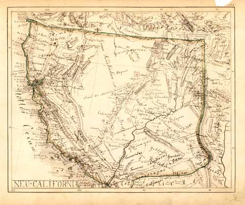
"NEU=CALIFORNIA"
from "Zeitungs-Atlas 2. Europa
außer Deutschland und
die übrigen Erdtheile."
A basic edition with 120 maps, 1849-52, and with the
handwritten title:
"Atlas über alle
bekannten Theile der Erde sowie über die wichtigste mathem. &
phys. Geographie von Herrmann J. Meyer Theil II. Hildburghausen
1852."
Manuscript,
drawn with brown ink, boundaries and islands with green watercolor. 21,5 x 26
cm, map no 103.
Not listed
in Carl I. Wheat: The maps of the California Gold Region, 1942 and 1995.
A
manuscript map of the area of the present-day States of California, Nevada,
Utah, and Arizona with borders to Oregon, New Mexico, Sonora (Mexico), and to
the Pacific Ocean.
The map
includes much up-to-date information about the area and period described, with
main emphasis laid on the recently discovered gold fields in the mining
district along the Sacramento valley.
The
indicated mining areas match very well with the ‘Gold & Quicksilver districts
of California’ shown at Edward O.C. Ord’s map from July 25th, 1848,
which had been the basis of President Polk’s historic message to the 30th
Congress of December 5th,
1848, officially announcing the discovery of gold and setting off the gold rush
of 1849.
Beside the
information on the mining districts, the map includes a lot of other details
about New California, written in German, Spanish, and English:
The
location of many missions and the roads between them.
The routes
of famous expeditions through the country, e.g. Capt. Fremont’s winter
expedition of 1843/44, discovering a convenient pass through the Sierra Nevada
range that was later named for his guide and co-discoverer Kit Carson – the
Carson Pass became the main gateway to California for the argonauts of 1849 and
remained such for several years – or the overland route by Capt. Smith 1828, or
the way from the Pacific coast to S. Fé …
Topographical
and geographical information.
Notes about the vegetation, e.g. ‘Fruchtbare waldige Ebenen
und Prairien`, ‚Ungeheure Tannenwälder’ ...
Historical notes, e.g. ‚Ehemalige Grenze zwischen den
Vereinigten Staaten u. Mexico nach dem Vertrag v. Florida vom 12. Januar 1828’ ...
and much
more details.
The map
includes information up to Mitchell’s ‚New map of Texas, Oregon and California’
from 1846 and Org’s ‚Topographical sketch of the gold & quicksilver
district of California’, July 25th, 1848, but not from the ‚Map of Oregon and
Upper California’ by John Charles Fremont and Charles Preuss published in late
1848 and early 1849. The ‘New map of the State California’ by Meyer,
Hildburghausen, 1852, listed by Wheat as no 222, already shows the boundaries
of California as laid down in the State Constitutional Convention of 1849.
It seems
that the described manuscript map was a personal item of one of the mapmakers,
who worked for the bibliographic institute in Hildburghausen, possibly of
Johann Grässl, who was responsible for the American maps in this atlas, or even
a private map of Herrmann Julius Meyer (1826 – 1909), the son and presumptive
heir of Joseph Meyer (1796 – 1856), who was sent to New York by his father just
at the beginning of 1849 to open a second office in the U.S.A.
At all the
map is a skillful and very detailed compilation of available information on
California up to 1849. It was drawn – maybe in several steps – 1849 or somewhat
later.
This
manuscript map provides an accurate and comprehensive description of the
southwestern part of North America for the very early period of the California
Gold Rush.
See
also under 'Old maps of Europe'
€ 7000,-
|