|
Ref.: Shirley, The Mapping of the World,
London 1983.
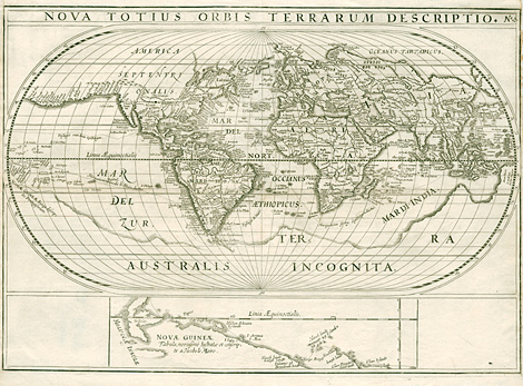
Rare historical document. One of the first
maps, which shows the circumnavigation of South
America (around Kap Hoorn) through the Strait
of Le Maire ('Fretum le Maire'), which had been
discovered just a few years before. The map
documents as well the discovery of New Ireland
and of the Schouten Islands northeast and north
of Papua New Guinea.
History of the voyages:
Jacob Le Maire (1585-1616) and Willem Cornelisz
Schouten (1580-1625) were hired by Dutch merchants
of Hoorn to find a new route to the Pacific
and to the Spice Islands, not sailing around
South Africa or through the Straits of Magellan.
On June 14, 1615 the expedition started with
the two vessels Eendracht and Hoorn from Texel
island in Holland. They sailed first to the
Canary Islands and to the western coast of Africa
(Sierra Leone), then they crossed via Trinidad
/ Martin Vaz the Atlantic Ocean and reached
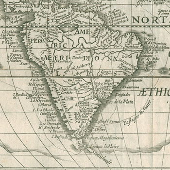
the coast of South America. Further to the south
they past the entrance to the Straits of Magellan
and continued going south. They discovered and
rounded the southern point of the continent
and called it - after the vessel Hoorn, which
they lost before - Cape Hoorn.
The strait between Tierra del Fuego and State
Island was named - in honour of one of the discoverers
- Le Maire Strait ('Fretum la Maire'). The State
Island is shown on the map as a peninsula of
the southern continent 'Terra Australis Incognita'.
Le Maire and Schouten continued their voyage
heading northwest towards Asia. On their voyage
they discovered some islands of the Tonga group.
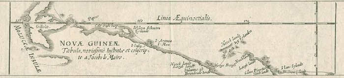
At the northeastern side of Papua New Guinea
they discovered New Ireland and at the northern
coastline of Papua New Guinea another group
of islands, which they called Schouten Islands.
Oktober 1616 they reached Java and the outpost
of the Dutch East India Company (V.O.C. - Vereenigde
Oostindische Companie) in Batavia.
Nearly at the same time Joris van Spilbergen
(1568-1620) travelled around the world. He was
hired by the Dutch East India Company to sail
from Holland through the Straits of Magellan
to Java. He started already in 1614 from Holland
via the Canary and Cape Verde Islands to Sao
Vicente at the coast of South America. From
there he went further south and through the
Straits of Magellan he reached the Pacific,
where he followed the coastline to the north
up to the Gulf of California. There he crossed
the pacific towards Asia roughly at 20 degrees
of latitude.
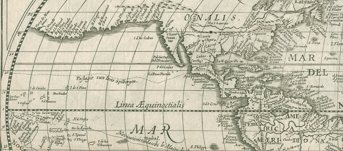
The western coast of North America is shown
on the map as a southern coastline far away
but parallel to the route he crossed the Ocean.
Spielbergen reached Java at about the same
time when Le Maire and Schouten arrived in Asia.
Both had been arrested by deputies of the Dutch
East India Company just when they arrived. The
V.O.C. claimed that they had infringed the company's
monopoly of trade. Nobody there believed them
that they found a new route from Holland to
Java.
Le Maire and Schouten were put under the
command of Admiral Spilbergen. 1616/17 they
went with his fleet - the Eendracht had been
confiscated in Java - via the Cape of Good Hope,
Ascension Islands and the Azores back to Europe.
Le Maire died during this journey.
Already 1617 Spilbergen published a short
account of the journey, but without a world
map. Schouten's account of his journey arround
the world with Le Maire was published by Willem
Jasz. (Blaeu) in Amsterdam 1618 and it was accompanied
by a smaller (15,5 x 23 cm) world map showing
the tracks of the vessel. The larger (31,5 x
45 cm) world map by Spilbergen with the tracks
of both voyages was published 1619 in Leiden.
An account by von Isaac Le Maire - the father
of Jacob - followed 1622.
|