Abraham Ortelius (1527-1598)
|
LH 0196
|
|
World and 4 continents
For one of the earliest
editions of Abraham Ortelius' atlas 'Theatrum
Orbis Terrarum'.
Antwerp 1571.
Outstanding examples
for the beautiful art of map-making during the
Renaissance period, in a perfect condition.
|
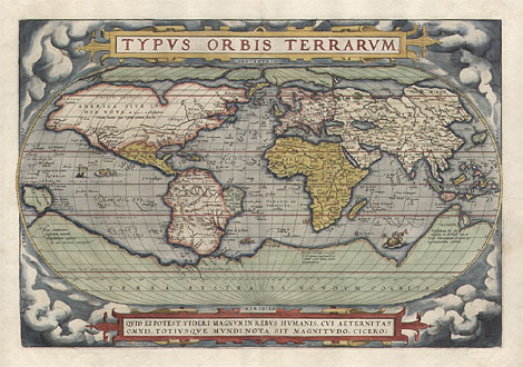
Map of the World:
"Typus Orbis Terrarum." - "Quid
ei potest videri magnum in rebus humanis, cui
aeternitas omnis, totiusque mundi nota sit magnitudo.
Cicero:" - "Cum Privilegio" -
"Franciscus Hogenbergus sculpsit"
First state of the decorative world map for
the Ortelius' atlas 'Theatrum Orbis Terrarum'.
Map with an oval circumference, surrounded by
clouds, with a title cartouche above and a quotation
from Circero below. Encouraged by Mercator,
Ortelius assembled his map from the best available
up-to-date maps, especially from Mercator's
large world map which had been published 1569.
Verso with Latin text. Engraved by Frans Hogenberg
(1535-1590). Mercator's own world map for an
atlas was made and published serveral years
later, 1587, by his son Sohn Rumold (see LH
0296).
Coloured copper engraving, engraved by Frans
Hogenberg, Antwerp 1571, 34 x 50 cm.
Very nice and clean item in a perfect condition,
printed on strong paper.
Ref.: Shirley 122/1; van den Broecke 1.1
Map of the World: sold
|
| 
|
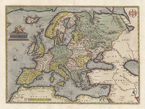
Europe:
"Europae" - "Cum privilegio"
First state of the map Europe for the Ortelius'
atlas 'Theatrum Orbis Terrarum'. After Mercator's
map of Europe from 1554 and his world map from
1569. Verso with Latin text.
Coloured copper engraving, Antwerp 1571,
34,5 x 46,4 cm.
Very nice and clean item with broad margins.
Uppermost centrefold a little bit open, otherwise
perfect condition.
Ref.: van den Broecke 4.1
Europe: sold
|
| 
|
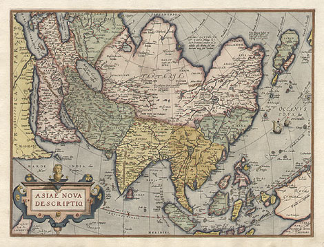
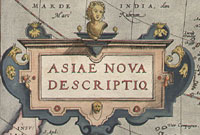
Asia:
"Asiae nova descriptio." - "Cum
privilegio."
First state of the map of Asia for the Ortelius'
atlas 'Theatrum Orbis Terrarum'. After his own
large map of Asia from 1567 which he assembled
after Gastaldi (c1500-1565) and Abulfeda (1273-1331).
Verso with Latin text.
Coloured copper engraving, Antwerp 1571,
37,5 x 50 cm.
Very nice and clean item in a perfect condition,
printed on strong paper.
Ref.: van den Broecke 6.1
Asia: 2.400,-
|
| 
|
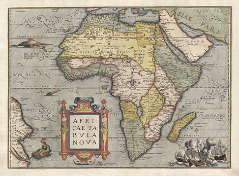
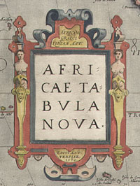
Africa:
"Africam Graeci Libyam App. / Africae
Tabula Nova / Edita Antverpiae 1570." -
"Cum Privilegio"
First state of the map of Africa for the
Ortelius' atlas 'Theatrum Orbis Terrarum'. With
a large and decorative title cartouche, with
sea monsters in the Atlantic and with a sea
battle at the lower right part. After Gastaldi's
map of Africa from 1564 and Mercator's world
map from 1569. Verso with Latin text.
Coloured copper engraving, Antwerp 1571,
37,5 x 50,5 cm.
Very nice and clean item, printed on strong
paper. With a few, tiny holes at centrefold,
otherwise perfect condition.
Ref.: van den Broecke 8.1
Africa: 2.350,-
|
| 
|
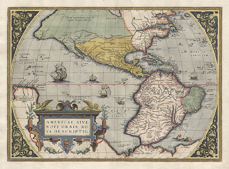
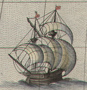
America:
"Americae sive novi orbis, nova descriptio."
- "Cum Privilegio."
Early state of the map of America for the
Ortelius' atlas 'Theatrum Orbis Terrarum'. Decorated
with a large title cartouche, sea monsters and
sailing boats. After Mercator's world map from
1569. Verso with Latin text, the second text
line starts with 'dinem' (compare van den Broecke
p 49).
Coloured copper engraving, Antwerp 1571,
37 x 51 cm.
Very nice and clean item in a perfect condition,
printed on strong paper.
Ref.: van den Broecke 9.2
America: 8.200,-
|
Abraham Ortelius (1527-1598)
|
| Cartographer
and publisher in Antwerp. 1570 he edited the
first modern atlas with maps in a uniform format.
His 'Theatrum Orbis Terrarum' was published
in several revised and enlarged editions and
in different languages until 1612.
|
| Enlarged Pictures |
Back |
Kunstantiquariat Monika Schmidt Munich
Germany www.maps-n-views.com
|
|