Johann Baptist Homann (1663-1724)
|
LH 0396
|
|
World and 4 continents
Early state with
California as an island.
Nuremberg 1716.
Beautiful
examples for the excellent baroque art of map-making.
10.800,-
|
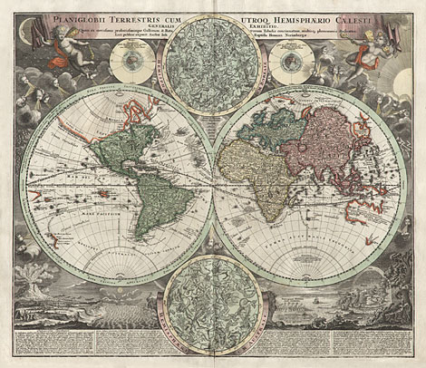
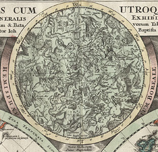
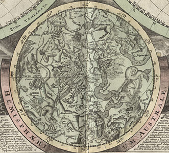
Map of the World:
"Planiglobii Terrestris cum utroq Hemisphaerio
Caelesti generalis exhibitio. Quam ex novissimis
probatissimisque Gallorum & Batavorum Tabulis
concinnatam, multisq. phaenomenis illustratam.
Luci publicae exponit Auctor Ioh Baptista Homann
Norimbergae."
Decorative map of the World in 2 hemispheres
with many illustrations and inset maps. In the
upper part with a celestial map of the northern
hemisphere and with maps about the summer and
winter solstice, surrounded by windheads and
clouds. In the lower part with a celestial map
of the southern hemisphere, at the left- and
right-hand side with descriptions and illustrations
of natural phenomena like volcanism, earthquakes,
tides, waves, currents, rain and rainbows. References
to the climes, described in a more detailed
way in the maps of the continents, we can find
in the edges of the hemispheres.
Originally coloured copper engraving, Nuremberg
1716, 49 x 57,3 cm.
Early state with California as an island.
Very nice and strong original colours. Paper
a little bit peeled off at centrefold and with
neatly repaired tears at the lowermost part,
lower left corner replaced, otherwise very good
condition.
|
| 
|
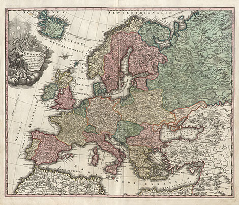
Europe:
"Europa Christiani Orbis Domina in sua
Imperia Regna et Status exacte divisa per Iohann.
Bapt. Homann Sac. Caes. Maj.tis Geographum Norimbergae."
Map od Europe with a smaller, decorative
title cartouche and a subdivision of the latitudes
into climes with their longest sunshine duration.
Originally coloured copper engraving, Nuremberg
1716, 49,5 x 59,2 cm.
Countries with nice and strong original full
colours, cartouches black-and-white. Paper a
little bit peeled off at centrefold. Upper right
margin, outside of the map, restored, otherwise
very good condition.
|
| 
|
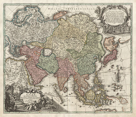
Asia:
"Asiae Recentißima Delineatio, qua Status
et Imperia Totius Orientis unacum Orientalibus
Indiis exhibentur. Authore Ioh. Bapt. Homann
Sac. Caes. Maj. Geograph Norimber"
Map of Asia with a decorative title cartouche
at lower left and with an additional cartouche
with a text for the observer at upper right
and with a subdivision of the latitudes into
climes with their longest sunshine duration.
Originally coloured copper engraving, Nuremberg
1716, 49,2 x 58 cm.
Countries with nice and strong original full
colours, cartouches black-and-white. Lower margin
at centrefold a little bit restored, otherwise
very good condition.
|
| 
|
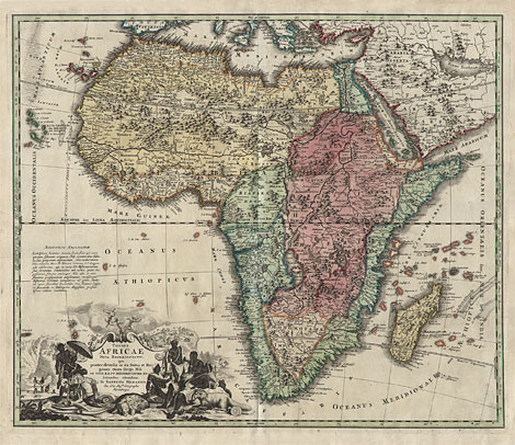
Africa:
"Totius Africae Nova Repraesentatio,
qua praeter diversos in ea Status et Regiones
etiam Origo Nili ex veris RR.PP. Mißionariorum
Relationibus ostenditur á Io Baptista Homanno
Sac. Caes. Maj.tis Geographo Norimbergae."
Map of Africa with the Canary Islands, the
Cape Verd Islands, the Seychelles and Madagascar.
With a decorative title cartouche and with a
text for the observer above and with a subdivision
of the latitudes into climes with their longest
sunshine duration.
Originally coloured copper engraving, Nuremberg
1716, 49,3 x 58,3 cm.
Countries with nice and strong original full
colours, cartouches black-and-white. Upper margin
a little bit creased, otherwise perfect condition.
|
| 
|
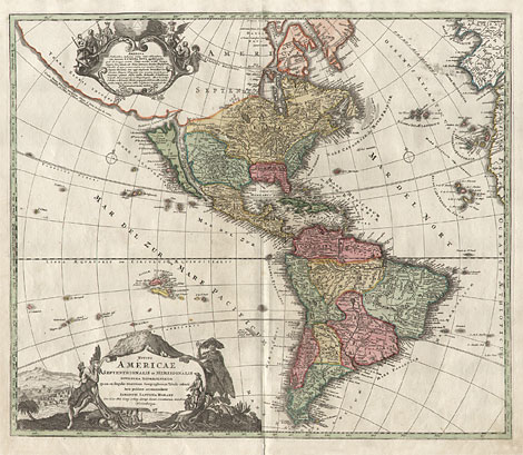
America:
"Totius Americae Septentrionalis et
Meridionalis Novissima Repraesentatio
quam ex singulis recentium Geographorum Tabulis
collecta luci publicae accommodavit Iohannes
Baptista Homann Sac. Caes. Mai. Geog. + Reg.
Boruß. Societ. Scientiarum membrum Norimbergae."
Map of North and South America, with California
as an island. Decorative title cartouche at
lower left and a cartouche with a text about
America at upper left and with a subdivision
of the latitudes into climes with their longest
sunshine duration.
Originally coloured copper engraving, Nuremberg
1716, 49,2 x 58 cm.
Countries with nice and strong original full
colours, cartouches black-and-white. Lower margin
at centrefold a little bit restored, otherwise
very good condition.
|
Celestial inset charts of the world map:
|
| 
|
Johann Baptist Homann (1663-1724)
|
| Copper
engraver, cartographer and publisher. First
he worked for other publishers, e.g. for Jacob
von Sandrart (1630-1708), David Funcke (worked
1680-1725) and Heinrich Scherer (1628-1704).
In 1702 he founded his own publishing house.
|
| Enlarged Pictures |
Back |
Kunstantiquariat Monika Schmidt Munich
Germany www.maps-n-views.com
|
|