|
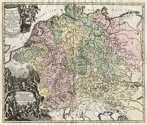
Hydrographic map of Central Europe
"Hydrographia Germaniae qua Geographiae
Naturalis ea pars quae de Aquis celebrioribus praesertim
vero de Fluminibus Germaniae agit ..."
Copper engraving with a nice original colouring,
published by Johann Baptist Homann after Philipp
Heinrich Zollmann, with privilege, Nuremberg about
1730, 49 x 58 cm.
Perfect impression, a little bit restored at
centrefold, otherwise very good condition.
420,-
|
| First special map of the rivers and lakes in
Central Europe from the North and Baltic Sea to
the Vistula river in the East and to the Gulf of
Venice in the South. Large, decorative title cartouche
at lower left with sea and river gods and products
of the sea and rivers like fishes, shells and pearls.
At uppper left a cartouche with a dedication to
Friedrich Christian Baron v. Edelheim, Earl of Hanau-Münzenberg,
by the draughtsman of the map Philipp Heinrich Zollmann.
Ref.: Cartographia Bavariae, Bayerische Staatsbibliothek,
catalogue 44, 1988, Fig. 281.
|