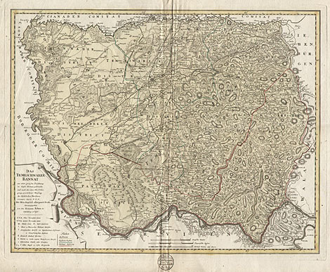
Banat, Timisoara, Romania
"Das Temeschwarer Bannat aus einer grossen
Zeichnung in dieses Format gebracht und nach der,
vom Hrn. P. Liesganig geschehener Messung des Kistelecken
Meridians orientirt durch F. L. G. Mit Röm. Kayserl.
allergnaed. Freyh. herausgegeben von den Homann.
Erben in Nurnberg 1790."
Map of the Banat region with the capital city
Timisoara. Shown is the area between the rivers
Tisza, Maros (Mures) and Danube and the foothills
of the southern Carpathian Mountains, a region where
today the three countries Romania, Hungary and Serbia
meet. Title cartouche and a legend at lower left.
With a stamp of the 'Gebrüder Kirchmayer an der
Langen Brücke in Berlin' below the map.
Original coloured copper engraving, made by Franz
Ludwig Güssefeld (1744-1807) after Joseph Liesganig
(1719-1799), and published by Homann Heirs, Nürnberg
1790(d). 50 x 63 cm.
Very good impression, a little bit creased at
centrefold and somewhat damaged at outer marginsim,
otherwise very good condition.
420,-
|