Homann Heirs
|
LO 3788
|
|
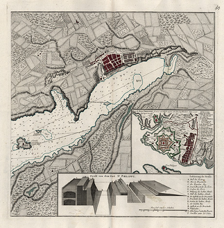
The Balearic Islands
Minorca, Mahon,
St. Philip's Castle
"Plan des Forts Phillippe ..."
"Profil
von dem Fort St. Phillippe."
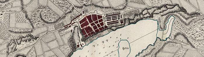
Map of the northern part of the port of Mahon
at Minorca, with a detail map of the fortification
of St. Philip's Castle, the protecting fort
at the entrance of the port of Mahon, and with
a profile through the fortifications of St.
Philip's Castle.
Orig. coloured copper engraving by Homann
Heirs, Nuremberg about 1760, 45 x 45 cm.
Very good impression and condition, broad
margins, on strong paper.
420,-
|
|
Some details of the map:
|
|
|
|
Johann Baptist Homann (1663-1724). Engraver,
cartographer and publisher in Nuremberg. Worked
first of all for other publishers as Jacob von
Sandrart, David Funcke and Heinrich Scherer,
and founded his own firm 1702.
Homann Heirs. Successors of J.B. Homann.
The company traded under the name of 'Homännische
Erben' (Homann Heirs) from 1730 and under the
name of Ch. Fembo from 1813 on.
June 29, 1756, after the siege of St. Philip's
Castle, the Port of Mahon and Minorca was captured
from Britain by the French marshal Louis François
Armand du Plessis, a duc de Richelieu (1696-1788).
A smaller affair, but it represented the outbreak
of the Seven Years' War in the European theatre.
|
| Enlarged Picture |
Back |
Kunstantiquariat Monika Schmidt Munich
Germany www.maps-n-views.com
Antique Shop for Rare Old Prints: Old
Maps, Views, and Decorative Prints with
original
copper engravings, etchings, lithographs, steel engravings, woodcuts
|
|