Robert de Vaugondy
|
LP 0629
|
|
California, Baja California peninsula, Gulf
of California
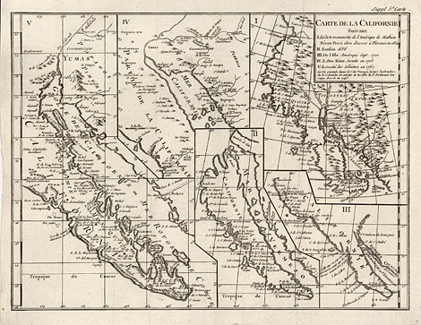
"Carte de la Californie suivant
I.
la Carte manuscrite de l'Amerique de Mathieu
Neron Pecci olen dresses a Florence en 1604
II.
Sanson 1656
III. de l'Isle Amerique Sept.
1700
IV. le Pere Kino Jesuite en 1705
V.
la Societe des Jesuites en 1767"
Copper engraving by Didier Robert de Vaugondy,
Paris 1770, 29,5 x 49 cm.
Very good impression and condition.
sold
|
|
5 detail maps of California and the Baja
California peninsula differently seen by cartographers
of the 17th and 18th century, starting with
Mathieu Neron Pecci ('Wall map America' 1604),
followed by Nicolas Sanson (California depicted
as an island, 1656) and Jesuits of the 18th
century (California seen as a peninsula). Compiled
by Robert de Vaugondy for the supplements (Suppléments,
'Suppl. 5. Carte') of the 'Encyclopédie, ou
Dictionnaire raisonné des sciences, des arts
et des métiers' by Denis Diderot and Jean Baptiste
le Rond dAlembert (from 1770 edited by Jean-Baptiste
Robinet and published by Charles-Joseph Panckoucke).
Didier Robert de Vaugondy (1723 - 1786).
Royal
geographer and publisher of atlases in Paris.
Worked together with his father Gilles Robert
de Vaugondy. Their atlases were reissued by
Charles Francois Delamarche (1740 - 1817) from
1792 on.
|
| Enlarged Picture |
Back |
Kunstantiquariat Monika Schmidt Munich
Germany www.maps-n-views.com
Antique Shop for Rare Old Prints: Old
Maps, Views, and Decorative Prints with
original
copper engravings, etchings, lithographs, steel engravings, woodcuts
|
|