Mercator, G. / Hondius, J.
|
LT 041210
|
|
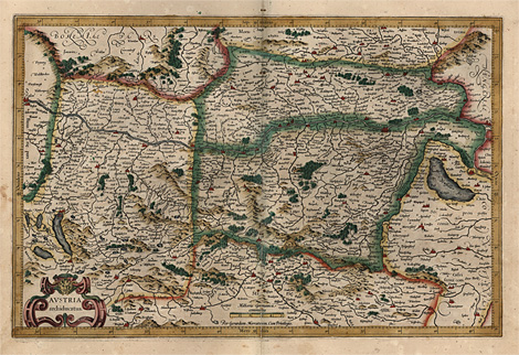
Austria > Upper and Lower Austria
"Austria Archiducatus"
Orig. coloured copper engraving by Gerard
Mercator, published by J. Hondius, Amsterdam
1612, with privilege, 32,5 x 48,5 cm.
Perfect impression and condition, on strong
paper, with wide margins, very nice and fresh
original colours.
475,-
|
|
Decorative map of Upper and Lower Austria,
with the course of the Danube River from Passau
to Bratislava and adjacent countries (Bohemia
and Moravia in the North, Hungary in the East).
Gerard Mercator (1512 1594)
Cartographer, mathematician and globemaker.
Pupil of Gemma Frisius in Louvain. From 1537
independent cartographer, moved to Duisburg
1552. There he made his most famous maps as
the world map with Mercator's Projection at
18 sheets (1569). From 1585 he issued his atlas
in single parts. The complete atlas was published
posthumously 1595 and 1602, reissued by J. Hondius
in Amsterdam from 1606 on. Some of his maps
were bought by Blaeu 1629 and later on re-published.
Hondius
Family of engravers, cartographers and publishers
in Amsterdam. Jodocus Hondius (1563 - 1612)
aquired the plates for the Mercator atlas 1604,
which he reissued - with texts by his brother-in-law
Petrus Montanus - in a new enlarged edition
(published by H. Hondius till 1641). His sons
Jodocus Hondius jun. (1594 - 1629) and Henricus
Hondius (1597 - 1651) took over the firm, continued
by Henricus Hondius together with his brother-in-law
J. Janssonius from 1630 on.
|
| Enlarged Picture |
Back |
Kunstantiquariat Monika Schmidt Munich
Germany www.maps-n-views.com
Antique Shop for Rare Old Prints: Old
Maps, Views, and Decorative Prints with
original
copper engravings, etchings, lithographs, steel engravings, woodcuts
|
|