|
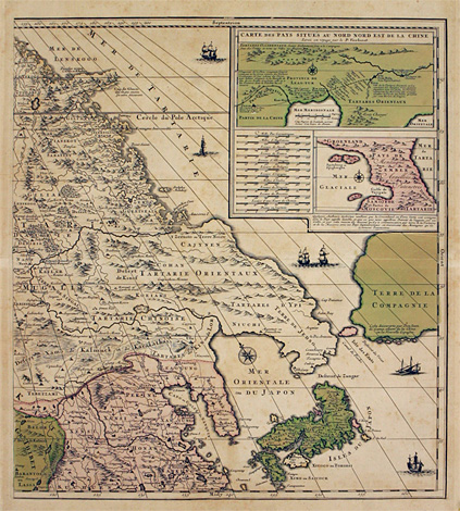
Northeastern Asia, Japan
Right part of a large map of Northern Asia,
its northeastern part with Tartary, Korea, parts
of China and with the islands of Japan.
Orig. coloured copper engraving by Alexis-Hubert
Jaillot, Paris about 1690-1700, 55 x 50 cm.
Very good impression, nice original colours,
paper throughout somewhat stained and brownish,
otherwise very good condition.
680,-
|
|
Two inset maps at upper right:
a) "Carte de Pays Situés au Nord Nord
Est de la Chine. Levée en voyage par le P. Verbiest"
- Inset map with the Liaodong Bay and the Korea
Bay, with Beijing and the province of Beijing
and with parts of the Great Wall of China.
b) Below twelve different scales and a fictitious
map of a land bridge between the Yamal Peninsula
and Greenland, including Severnay and/or Novaya
Zemlya and passing Svalbard.
Alexis-Hubert Jaillot (1632 1712)
Engraver, cartographer and publisher in Paris.
Pupil of N. Sanson. From 1689 he published large
folio atlases with maps after N. Sanson in co-operation
with Guillaume and Adrien Sanson.
|
Kunstantiquariat Monika Schmidt Munich
Germany www.maps-n-views.com
Antique Shop for Rare Old Prints: Old
Maps, Views, and Decorative Prints with
original
copper engravings, etchings, lithographs, steel engravings, woodcuts
|