|
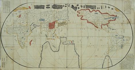
Large sized map of the world, woodblock print,
contemporarily coloured by hand, edited by Onogi
Ichibei and Asa Shoemon from Kyoto (mentioned in
the text), published in Osaka 1783, dated: Tenmei
12. month.
Characteristic feature of the map: Japan is in
the centre, Europa and Afrika at the western margin,
America in the East. Outside of the map, at the
four corners, there are annotations and legends
in Japanese characters.
Map formerly several times folded, more recently
mounted on Japanese paper.
Very rare map of the world. Listed at Beans List
of Japanese Maps of the Tokugawa Era, but without
picture. Under: Maps of the Tenmei Period (1781-1789),
described as first world map of this period: 1783.1
and first state. Later editions, as 1783.3, have
added a second name of a publisher and are are not
coloured by hand but printed in colours.
Very good impression, paper somewhat stained
due to its age and partly a little bit damaged at
former folds, otherwise good condition.
|
Kunstantiquariat Monika Schmidt Munich
Germany www.maps-n-views.com
Antique Shop for Rare Old Prints: Old
Maps, Views, and Decorative Prints with
original
copper engravings, etchings, lithographs, steel engravings, woodcuts
|