J.M. Hase by Homann Heirs
|
LK 2467
|
28 historical maps from the Ancient World until
the Modern Age (1740)
Originally coloured copper engravings, 1 title
and 28 maps printed on 9 large double-pages (see
below page 1 to 9), after Johann Matthias Hase,
published by Homann Heirs, Nuremberg 1746(d). Size
of the pages: Each about 55 x 63 cm. Size of each
single map see below.
All in a perfect impression and condition.
Ref.: Johannes Dörflinger. Geschichtskarten und
Geschichtsatlanten des Verlages Homann. In: "auserlesene
und allerneueste Landkarten", Stadtarchiv Nürnberg,
catalogue 14, 2002, pp 150.
2.750,-
|
| Page
1:
|
|
|
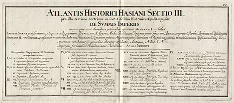
| Title:
"Atlantis Historici Hasiani Sektio III.
pro illustratione doctrinae in Sect. I. de Idea
Hist. Univers. polit. expositae de Summis Imperiis
...", 23,5 x 55 cm.
|
|
|
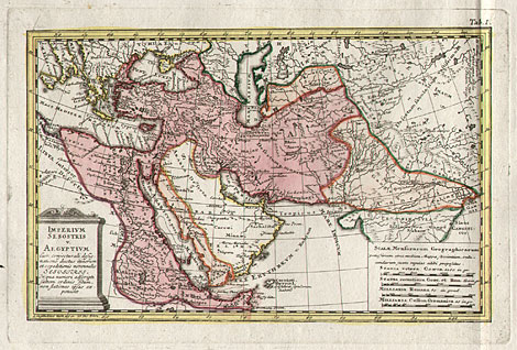
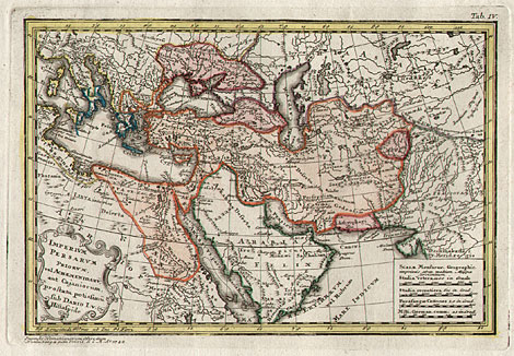
| 1) "Imperium Sesostris vel Aegyptium ...",
19,5 x 29 cm.
|
|
|
| 2) "Imperium Assyrium integrum ...",
18,5 x 26,5 cm.
|
| The historical maps edited by Homann Heirs cover
- quantitatively seen - only a small part of the
total editions produced, but have an outstanding
importance for the reputation of the publishing
house through the quality of their contents and
innovation.
The most important historical maps of the Homann
publishing house are the larger as well as smaller
sized maps by Johann Matthias Hase (1684-1742),
a professor at the university of Wittenberg.
Hase, son of a teacher of mathematics in Augsburg,
first studied theology in Helmstedt and from 1704
mathematics in Leipzig. Through his work as a private
teacher for a noble family in Augsburg he took a
closer look at geography and cartography. 1719 he
became a professor for mathematics at the university
of Wittenberg, where he worked for more than 22
years.
During the 30th of the 18th century Hase started
to make maps for the Homann publishing house. As
a cartographer who realy made reseach into sources
he can be listed together with Guiaume Delisle (1675-1716)
and Jan-Baptist d'Anville (1697-1782). Main interest
he brought into the geographic-political history
of the regions of Europe, Northern Africa and Near
East.
|
| Page
2:
|
|
|
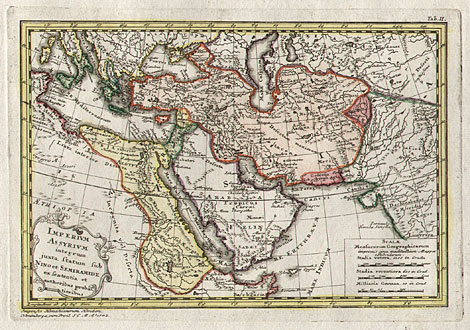
| 3) "Imperii Assyriaci dissoluti parta, Regna
Medorum, Babylonio-Caldaerum, Lydorum ...",
18,5 x 30,2 cm.
|
|
|
| 4) "Imperium Persarum primorum ...",
18,4 x 26,9 cm.
|
|
|
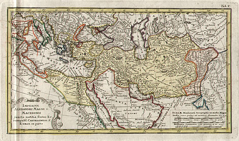
| 5) "Imperium Alexandri Magni v. Macedonis
...", 18,5 x 31,8 cm.
|
| For his universal history ("Historiae universalis
politicae ...", Nürnberg 1743) he created 28
smaller-sized maps about the historical development
of the kingdoms and empires of the eastern hemisphere.
The maps cover a period of several thousand years,
from the 20th century BC (Egypt under Sesostris
I) until 1740 (Roman-German Empire at the time when
Charles IV died). 10 maps are dealing with the Ancient
World, 12 with the Middle Ages und 6 with the New
Age.
|
| Page
3:
|
|
|
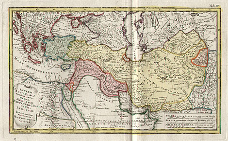
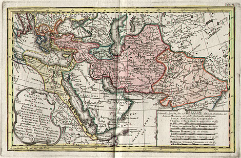
| 6) "Imperii Graecorum, vel Epigonorum, h.e.
Successorum Alexandri M. ...", 18,3 x 28,2
cm.
|
|
|
| 7) "Imperii Graecorum Periodus altera ...",
18 x 31,5 cm.
|
|
|
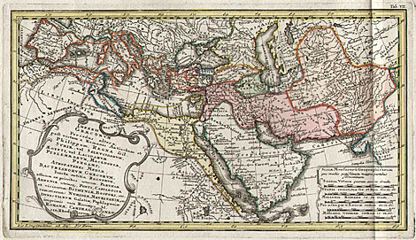
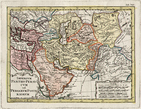
| 8) "Imperium Partho-Persicum vel Persarum
Posteriorum", 19,5 x 25 cm.
|
| The maps mark a turning point in the history
of cartography, because in several respects the
range of these maps is quite unusual for that time.
First their contents reach up to recent times and
do not only deal with Europe or the Mediterranean
area, second they had a large circulation, because
they were printed and not only drawn.
An other speciality was that the maps of a region
were grouped together to allow the user a better
understanding of the course of the historical events.
This is given especially for our edition of the
maps, where 3 or 4 maps are printed on one page.
|
| Page
4:
|
|
|
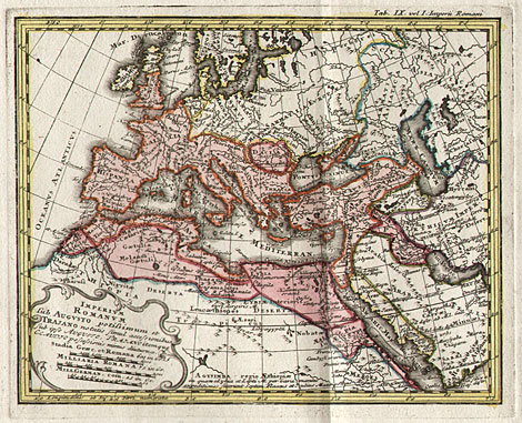
| 9) "Imperium Romanum sub Augusto potissimum
et Trajano ...", 18,4 x 22,5 cm.
|
|
|
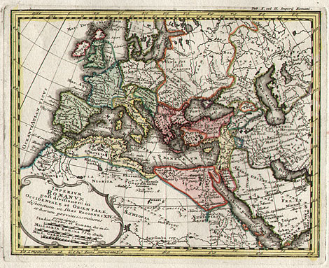
| 10) "Imperium Romanum post divisionem in
Occidentale et Orientale ...", 18,2 x 22,8
cm.
|
|
|
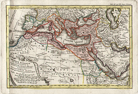
| 11) "Imperium Romanum sub Justitiano I.
...", 19 x 28 cm.
|
| The maps illustrate the regional expansion (or
regession) of 5 important empires. These are the
Roman Empire (from about 0 until the 6th century),
the 'Arab' Empire (from about 750 until 1100), the
Franconian or Roman-German Empire (from Charlemagne
until 1740), the Mongol Empire (from about 1275
until the 18th century), the Ottoman or Turkish
Empire (from the conquest of Constantinople, 1453,
until the Treaty of Passarowitz, 1718).
The areas of the empires mentioned are indicated
at the maps by carefully applied full colours while
the other territories are shown with outline colours
only.
From 1746 the maps were published as an historical
atlas as well, where the title and the 28 maps are
printed on 9 large pages
|
| To the next maps (pages 5 to
9, maps 12 bis 28) --->> |
Enlarged Pictures |
Back |
Kunstantiquariat Monika Schmidt Tel.
+ 89 28 42 23
Germany www.maps-n-views.com
|
|