WSM 01413
Western Europe - British Isles: England,
Scotland, Ireland
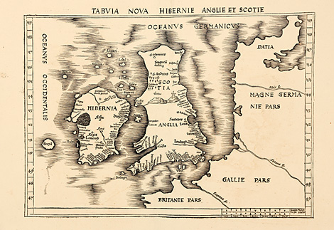
Tabula Nova Hibernie Anglie et Scotie
Map of the British Isles with the coastline
from Brittany (Bretagne) to Denmark, from the
supplement of Ptolemy's Geographia by Waldseemüller.
One of the first printed 'modern' maps of
England, Scotland and Ireland. Waldseemüller
revised the coastlines and added several towns,
e.g. London at the Themse river.
Woodcut map from the supplement of the Geographia
by Martin Waldseemüller, published by Jakob
Äschler and Georg Übelin, printed by Johannes
Schott, Straßburg 1513, 36 x 51,5 cm (map size).
Perfect condition, wide margins.
7.850,-
|
Kunstantiquariat Monika Schmidt Munich
Germany www.maps-n-views.com
Antique Shop for Rare Old Prints: Old
Maps, Views, and Decorative Prints with
original
copper engravings, etchings, lithographs, steel engravings, woodcuts
|