(1470 Wolfenweiler
nearby Freiburg
/ Breisgau -
Saint-Dié ca.
1518)
Martin Waldseemüller,
the famous cartographer
and member of
the circle of
scholars in
Saint-Dié (Saint-Dié-des-Vosges,
Lorraine, France),
is well known
especially as
author of the
large world
map which he
made together
with Matthias
Ringmann (14821511).
This world map
is known as
the first one
to use the name
"America"
and was originally
published in
April 1507.
In the same
year Waldseemüller
also produced
a globular world
map, i.e. printed
globe gores,
designed to
be cut out and
pasted onto
spheres to form
globes of the
Earth. In 1511
he started to
create a wall
map of Europe
Carta Itineraria
Europea which
was published
in 1520. In
1516 he published
a second large
world map Carta
Marina Navigatoria.
His Strasbourg
Ptolemy edition
was published
- 500 years
ago - in 1513.
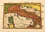
It is one of
the most important
map collections
made after Ptolemy.
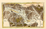
To the 27 woodcut
maps created
after Ptolemy's
descriptions
a supplement
was added with
20 new maps
('Tabula Nova').
Both parts starts
with a world
map followed
by maps of Europe,
North Africa
and Asia.
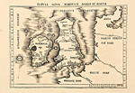
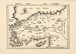
The first
map of the supplement
is a world map
called Carta
Marina, made
in the style
of a sea chart
and with a aprt
of the American
continent shown.
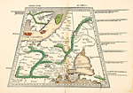
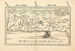
The next map
is one of the
Atlantic Ocean,
again with a
part of America
shown, but here
simply labelled
Terra Incognita,
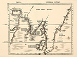
followed by
the 'modern'
maps of Europe,
Africa and Asia.
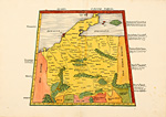
A second
edition of the
Geographia
was published
in Straßburg
about 1520.
The Tabula
Nova Helvetia
after Konrad
Türst was replaced
by another 'modern'
map of Switzerland.
Today the
woodcut maps
of Ptolemy's
Strasbourg edition
by Waldseemüller
are very rare
and much sought
after by map
collectors all
over the world.
|