WSM 02413
Central Europe - Germania, Germany
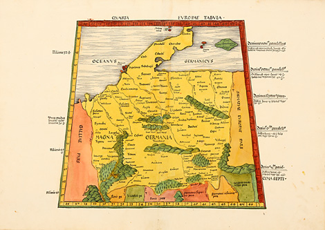
Quarta Europae Tabula
Map of Germany with adjacent countries. A
little bit trapeze-shaped in the style of Ptolemy.
Originally coloured woodcut map from Ptolemy's
Geographia by Martin Waldseemüller, published
by Jakob Äschler and Georg Übelin, printed by
Johannes Schott, Straßburg 1513, 37 x ca. 40
cm (map size).
Perfect condition, splendid original colours.
sold
|
Kunstantiquariat Monika Schmidt Munich
Germany www.maps-n-views.com
Antique Shop for Rare Old Prints: Old
Maps, Views, and Decorative Prints with
original
copper engravings, etchings, lithographs, steel engravings, woodcuts
|