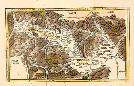
WSM 03413
The Upper Rhine Valley between Basel and
Mainz
Tabula Nova Particularis - Provincie Rheni
Superioris
Very detailed map of the Upper Rhine valley,
Strasbourg with its surroundings and adjacent
areas, between the Vosges mountains, the Black
Forest and the Forest of Odes. The Map is orientated
to the west.
Originally coloured woodcut map from the
supplement of the Geographia by Martin Waldseemüller,
published by Jakob Äschler and Georg Übelin,
printed by Johannes Schott, Straßburg 1513,
33 x 54 cm (map size).
Paper a littel bit water-stained at upper
and left margins, very small round wormholes,
otherwise very good condition, wide margins.
sold
|
Kunstantiquariat Monika Schmidt Munich
Germany www.maps-n-views.com
Antique Shop for Rare Old Prints: Old
Maps, Views, and Decorative Prints with
original
copper engravings, etchings, lithographs, steel engravings, woodcuts
|