WSM 04413
Eastern Europe - Sarmatia
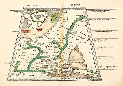
Ocatava Europe Tabula - Samartia Europe
Map of the European part of Sarmatia between
the Vistula and Don river and the Baltic and
Black Sea (Sea of Azov), with the areas of the
countries of the Baltic states, Poland, Hungary,
Romania, Ukraine, Belorussia, and Russia. Trapeze-shaped
in the style of Ptolemy.
Woodcut map from Ptolemy's Geographia by
Martin Waldseemüller, published by Jakob Äschler
and Georg Übelin, printed by Johannes Schott,
Straßburg 1513, 39 x ca. 49 cm (map size). Islands
and mountain chains originally coloured.
Very good condition, wide margins.
6.250,-
|
Kunstantiquariat Monika Schmidt Munich
Germany www.maps-n-views.com
Antique Shop for Rare Old Prints: Old
Maps, Views, and Decorative Prints with
original
copper engravings, etchings, lithographs, steel engravings, woodcuts
|