WSM 06413
Southeastern Europe - Alpine-Adria countries
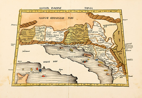
Quinta Europae Tabula
Map with the former countries Raetia, Vindelicia,
Noricum, Pannonia, Istria, Illyria, Dalmatia
(and Italy without any details). Trapeze-shaped
in the style of Ptolemy.
Originally coloured woodcut map from Ptolemy's
Geographia by Martin Waldseemüller, published
by Jakob Äschler and Georg Übelin, printed by
Johannes Schott, Straßburg 1513, 43,5 x 50 cm
(map size).
Perfect condition, wide margins.
sold
|
Kunstantiquariat Monika Schmidt Munich
Germany www.maps-n-views.com
Antique Shop for Rare Old Prints: Old
Maps, Views, and Decorative Prints with
original
copper engravings, etchings, lithographs, steel engravings, woodcuts
|