WSM 10413
India, Southeast Asia
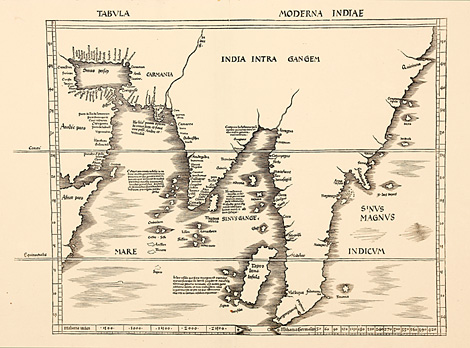
"Tabula Moderna Indiae"
'Modern' map of India and Southeast Asia,
from Eastern Africa and the Arabian Peninsula
to the Gulf of Thailand. Ealiest non-ptolemaic
('modern') depiction of India and western Southeast
Asia. First modern map of India !
Woodcut map from the supplement of the Geographia
by Martin Waldseemüller, published by Jakob
Äschler and Georg Übelin, printed by Johannes
Schott, Strasbourg 1513, 40 x 50,5 cm (size
of the map).
Perfect condition, wide margins.
sold
|
Kunstantiquariat Monika Schmidt Munich
Germany www.maps-n-views.com
Antique Shop for Rare Old Prints: Old
Maps, Views, and Decorative Prints with
original
copper engravings, etchings, lithographs, steel engravings, woodcuts
|