Home
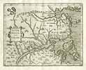
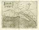
Old maps by C. Wytfliet
Contact Imprint Terms Data Security Sitemap Links Deutsch
Old Views Old Maps Decorative Prints Artists & Mapmakers Bookshop
Flemish cartographer. Published the first atlas with maps of America only. It contains 19 regional detail maps and information on the discovery, geography and natural history of North and South America, first published in Louvain, Belgium 1598.
Please, click on a picture for more information.
Canada
U.S.A. - California
Back to top